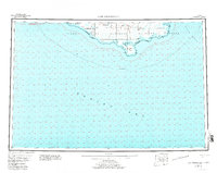
1952 Map of Cape Mendenhall
USGS Topo · Published 1982About this map
Nunivak National Wildlife Refuge dominates the landscape of this 1952 coastal Alaska survey, revealing a remote terrain defined by its complex shoreline and island topography. The map documents the intricate network of waterways like the Kiyakyalikaamiut River and the Binajokamiut River, which drain into the Bering Sea. Along the southern coast, the distinctive landforms of Cape Mendenhall and the vast Dahloongamiut Dunes illustrate the dynamic geological forces at work on Nunivak Island.
Find a feature on this map
24 named features on this map. Tap any name to fly to it.
Don’t see what you’re looking for? This feature index may not catch every label — zoom into the map to look around manually.
Map Details
Editions of this 1952 Cape Mendenhall Map
5 editions found
Other maps of this area

1951 · Kuskokwim Bay
USGS Topo · 1:250,000

1951 · Cape Mendenhall
USGS Topo · 1:250,000

1951 · Nunivak Island
USGS Topo · 1:250,000

1951 · Baird Inlet
USGS Topo · 1:250,000

1952 · Cape Mendenhall D-4
USGS Topo · 1:63,360

1952 · Cape Mendenhall D-3
USGS Topo · 1:63,360

1952 · Nunivak Island A-4
USGS Topo · 1:63,360

1952 · Nunivak Island A-7
USGS Topo · 1:63,360

1952 · Cape Mendenhall
USGS Topo · 1:250,000

1952 · Cape Mendenhall D-6
USGS Topo · 1:63,360