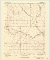
1968 Map of Capron
USGS Topo · Published 1971About this map
Capron stands as a focal point in this northern Oklahoma landscape, situated just south of the Kansas Oklahoma state line. The town is tied to the regional transport network by the Atchison Topeka and Santa Fe railroad, which cuts diagonally across the terrain toward Loder Siding. The map reveals a rural economy shaped by both agriculture and resource extraction, evidenced by scattered Oil Wells and a landscape bisected by a prominent pipeline. The winding path of Driftwood Creek and its tributary, Little Driftwood Creek, creates a distinct riparian corridor through the local townships of Driftwood, Cloud, and Keith. For those researching local family history, the Capron Cem provides a specific point of genealogical interest within this borderland region where Woods and Alfalfa counties meet.
Find a feature on this map
15 named features on this map. Tap any name to fly to it.
Don’t see what you’re looking for? This feature index may not catch every label — zoom into the map to look around manually.
Map Details
Editions of this 1968 Capron Map
3 editions found
Other maps of this area

1889 · Anthony
USGS Topo · 1:125,000

1891 · Medicine Lodge
USGS Topo · 1:125,000

1891 · Anthony
USGS Topo · 1:125,000

1893 · Medicine Lodge
USGS Topo · 1:125,000

1955 · Woodward
USGS Topo · 1:250,000

1955 · Pratt
USGS Topo · 1:250,000

1958 · Woodward
USGS Topo · 1:250,000

1959 · Pratt
USGS Topo · 1:250,000

1968 · Capron
USGS Topo · 1:24,000

1969 · Alva SE
USGS Topo · 1:24,000