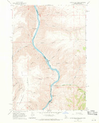
1968 Map of Captain John Rapids
USGS Topo · Published 1971About this map
The Snake River carves a deep path through the canyonlands along the Idaho-Washington border, defining the rugged geography of this 1960s survey. Navigational challenges and early river-based transport are evident in the naming of Captain John Rapids, Buffalo Rapids, and the nearby Steamboat Island. This stretch of the river served as a vital corridor for movement between Asotin County and Nez Perce County, anchored by landmarks like Captain John Ferry and Grahams Landing.
Find a feature on this map
32 named features on this map. Tap any name to fly to it.
Don’t see what you’re looking for? This feature index may not catch every label — zoom into the map to look around manually.
Map Details
Editions of this 1968 Captain John Rapids Map
2 editions found
Other maps of this area

1944 · Anatone
USGS Topo · 1:62,500

1945 · Clarkston
USGS Topo · 1:62,500

1946 · Limekiln Rapids
USGS Topo · 1:62,500

1946 · Anatone
USGS Topo · 1:62,500

1948 · Clarkston
USGS Topo · 1:62,500

1955 · Pullman
USGS Topo · 1:250,000

1958 · Pullman
USGS Topo · 1:250,000

1958 · Sweetwater
USGS Topo · 1:24,000

1958 · Lewiston Orchards South
USGS Topo · 1:24,000

1958 · Lewiston Orchards
USGS Topo · 1:62,500