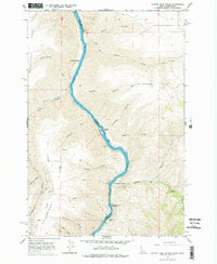
1968 Map of Captain John Rapids
USGS Topo · Published 1978About this map
The Snake River carves a deep path through the canyonlands along the Idaho and Washington border, defining the rugged geography of Nez Perce and Asotin counties. This 1968 field survey documents a river corridor shaped by navigation and early settlement, where Captain John Ferry and Grahams Landing served as vital transit points. The terrain is marked by steep ridges such as Weissenfels Ridge and Montgomery Ridge, with numerous drainages like Thiessen Canyon and Sandal Gulch feeding into the main channel. Smaller outposts like Crowers and Perkins appear on the higher ground, while the river itself features notable hazards and landmarks including Buffalo Rapids and Steamboat Island. A lone Cem near the South Fork Captain John Creek provides a tangible link for genealogists researching the families who inhabited these isolated canyon reaches before modern developments changed the landscape.
Find a feature on this map
39 named features on this map. Tap any name to fly to it.
Don’t see what you’re looking for? This feature index may not catch every label — zoom into the map to look around manually.
Map Details
Editions of this 1968 Captain John Rapids Map
2 editions found
Other maps of this area

1944 · Anatone
USGS Topo · 1:62,500

1945 · Clarkston
USGS Topo · 1:62,500

1946 · Limekiln Rapids
USGS Topo · 1:62,500

1946 · Anatone
USGS Topo · 1:62,500

1948 · Clarkston
USGS Topo · 1:62,500

1955 · Pullman
USGS Topo · 1:250,000

1958 · Pullman
USGS Topo · 1:250,000

1958 · Sweetwater
USGS Topo · 1:24,000

1958 · Lewiston Orchards South
USGS Topo · 1:24,000

1958 · Lewiston Orchards
USGS Topo · 1:62,500