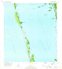
1958 Map of Captiva
USGS Topo · Published 1966About this map
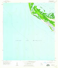
Barrier islands and protected waterways define this late-1950s coastal survey of Lee County, where Captiva Island and North Captiva Island are separated by the narrow Red Fish Pass. The small settlement of Captiva is centered around the historic Chapel by the Sea, which stands as a landmark of community life before the era of intensive development. To the east, the waters of Pine Island Sound are dotted with numerous keys and rookeries, including Josslyn Island and Benedict Key. The landscape is a network of shallow bayous and channels, such as Chatwick Bayou and Roosevelt Channel, which facilitated local navigation and fishing. This survey reveals the area in a state of relative isolation, accessible primarily by water via routes like Captiva Pass and Buck Key Channel, predating the modern road networks that would later connect these islands.
Find a feature on this map
38 named features on this map. Tap any name to fly to it.
Don’t see what you’re looking for? This feature index may not catch every label — zoom into the map to look around manually.
Map Details
Editions of this 1958 Captiva Map
5 editions found
Other maps of this area

1956 · Tampa
USGS Topo · 1:250,000

1956 · Charlotte Harbor
USGS Topo · 1:250,000

1958 · Matlacha
USGS Topo · 1:24,000

1958 · Captiva
USGS Topo · 1:24,000

1958 · Port Boca Grande
USGS Topo · 1:24,000

1958 · Sanibel
USGS Topo · 1:24,000

1958 · Pine Island Center
USGS Topo · 1:24,000

1958 · Bokeelia
USGS Topo · 1:24,000
1958 · Wulfert
USGS Topo · 1:24,000

1959 · Tampa
USGS Topo · 1:250,000