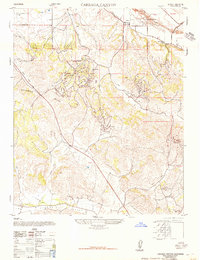
1947 Map of Careaga Canyon
USGS Topo · Published 1947About this map
Active Oil Fields and extensive petroleum infrastructure define the central landscape of these uplands during the late 1940s. Centered on the Solomon Hills, the area shows a transition from the industrial activity near Palmer and Roadamite to the agricultural reaches of the Los Alamos Valley. Educational sites like the Blochman School and Olive School provided for the local workforce and ranching families, while the presence of a Dismantled Railroad near Sisquoc indicates the shifting transportation needs of the era. North of the Sisquoc River, the map records early mining operations such as the Crushed Rock and Gravel Mine. From the heights of Tinaquaic down to the drainage of San Antonio Creek, the map details a terrain carved by Careaga Canyon and Solomon Canyon, reflecting the complex geography of Santa Barbara County's interior.
Find a feature on this map
24 named features on this map. Tap any name to fly to it.
Don’t see what you’re looking for? This feature index may not catch every label — zoom into the map to look around manually.
Map Details
Editions of this 1947 Careaga Canyon Map
3 editions found

Other maps of this area

1905 · Lompoc
USGS Topo · 1:125,000

1942 · Lompoc
USGS Topo · 1:125,000

1942 · Lompoc
USGS Topo · 1:62,500

1942 · Santa Maria
USGS Topo · 1:62,500

1942 · Tepusquet Peak
USGS Topo · 1:62,500

1942 · Los Olivos
USGS Topo · 1:62,500

1943 · Los Olivos
USGS Topo · 1:62,500

1943 · Tepusquet Peak
USGS Topo · 1:62,500

1943 · Lompoc
USGS Topo · 1:125,000

1947 · Lompoc
USGS Topo · 1:24,000