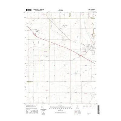
2016 Map of Carey
USGS Topo · Published 2016About this map
Agricultural lands at the intersection of Hancock, Seneca, and Wyandot counties characterize this part of Northwest Ohio. The village of Carey occupies the eastern edge of the map, serving as a focal point for regional transportation where numerous township and county roads converge. To the northwest, the smaller settlement of Vanlue is situated along a network of numbered trails and roads like Railroad St and Buffalo St. The terrain is marked by the prominent North Ridge and a series of drainage systems essential to the local farming economy, including Bacher Ditch, Number Thirtytwo Ditch, and Spring Run. Genealogists will find a high concentration of burial sites throughout the landscape, from the large Saint Marys Cem and Spring Grove Cem near Carey to smaller rural plots such as England Cem, Wentz Cem, and the dual locations of Lutheran Ridge Cem and Old Lutheran Ridge Cem.
Find a feature on this map
96 named features on this map. Tap any name to fly to it.
Don’t see what you’re looking for? This feature index may not catch every label — zoom into the map to look around manually.
Map Details
Editions of this 2016 Carey Map
This is the sole edition of this map. No revisions or reprints were ever made.
Other maps of this area

1901 · Fostoria
USGS Topo · 1:62,500

1903 · Fostoria
USGS Topo · 1:62,500

1903 · Findlay
USGS Topo · 1:62,500

1905 · Arlington
USGS Topo · 1:62,500

1907 · Arlington
USGS Topo · 1:24,000

1907 · Upper Sandusky
USGS Topo · 1:62,500

1950 · Marion
USGS Topo · 1:250,000

1956 · Toledo
USGS Topo · 1:250,000

1960 · Alvada
USGS Topo · 1:24,000
1960 · New Riegel
USGS Topo · 1:24,000