
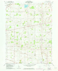
1960 Map of Alvada
USGS Topo · Published 1961About this map
The Old Indian Treaty Boundary slices diagonally across this portion of Hancock and Seneca counties, a lasting mark on the landscape that still dictates property lines and road orientations. The rural character of Alvada and West Independence is centered around a network of country churches and family burial grounds, including the SS Peter and Paul Ch and Biglick Cem. The Chesapeake and Ohio railroad corridor provides a primary industrial axis, passing through the southeastern corner near Springville. Agricultural drainage is clearly defined by The Outlet and the East Branch Portage River, while the northern reaches show the impact of municipal utility with the Fostoria Reservoir. This 1960 era survey also documents mid-century local landmarks like the Radio Towers (WFOB) and a Drive-in Theater, reflecting the intersection of traditional farming life and modern commercial development.
Find a feature on this map
28 named features on this map. Tap any name to fly to it.
Don’t see what you’re looking for? This feature index may not catch every label — zoom into the map to look around manually.
Map Details
Editions of this 1960 Alvada Map
2 editions found
Other maps of this area

1901 · Fostoria
USGS Topo · 1:62,500

1903 · Fostoria
USGS Topo · 1:62,500

1903 · Findlay
USGS Topo · 1:62,500

1905 · Arlington
USGS Topo · 1:62,500

1907 · Arlington
USGS Topo · 1:24,000

1907 · Upper Sandusky
USGS Topo · 1:62,500

1950 · Marion
USGS Topo · 1:250,000

1956 · Toledo
USGS Topo · 1:250,000

1960 · Bloomdale
USGS Topo · 1:24,000
1960 · Bascom
USGS Topo · 1:24,000