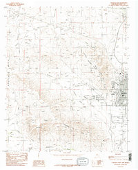
1985 Map of Carlsbad West
USGS Topo · Published 1985About this map
Lake Avalon and the Pecos River define the eastern edge of this mid-1980s landscape, where water management and industrial infrastructure meet the arid New Mexico terrain. The map captures the western expansion of Carlsbad into the Ocotillo Hills, including the residential pocket of Happy Valley and the educational grounds of Living Desert State Park. Tracing the western canyons and mesas reveals several named water sources such as Mc Kitric Spring and Lassiter Spring, which were vital markers for livestock and travelers in this environment. The Southern Pacific railroad corridor runs parallel to the river, servicing the growing urban center. Away from the city, the topography is dominated by massive features like Azotea Mesa and Adobe Flat, segmented by a network of drainage channels including Hackberry Draw and Soapberry Draw.
Find a feature on this map
32 named features on this map. Tap any name to fly to it.
Don’t see what you’re looking for? This feature index may not catch every label — zoom into the map to look around manually.
Map Details
Editions of this 1985 Carlsbad West Map
2 editions found
Other maps of this area

1939 · Carlsbad
USGS Topo · 1:62,500

1943 · Carlsbad
USGS Topo · 1:62,500

1943 · Oil City
USGS Topo · 1:62,500

1943 · West Carlsbad
USGS Topo · 1:62,500

1945 · West Carlsbad
USGS Topo · 1:62,500

1954 · Seven Rivers
USGS Topo · 1:24,000

1954 · Carlsbad
USGS Topo · 1:250,000

1955 · Lake Mc Millan South
USGS Topo · 1:24,000

1958 · Carlsbad
USGS Topo · 1:250,000

1978 · Artesia
USGS Topo · 1:100,000