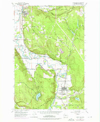
1953 Map of Carnation
USGS Topo · Published 1976About this map
The Snoqualmie River carves a broad valley through the center of this region, which was captured during a period of transition in the mid-1950s and updated into the early 1970s. The town of Carnation sits at the junction of the river and the Tolt River, serving as a focal point for the surrounding dairy lands and rural communities. Notable agricultural history is visible at the large Carnation Farm complex, while the transport network is defined by the Chicago Milwaukee St Paul and Pacific line and an old railroad grade tracing the valley floor.
Find a feature on this map
44 named features on this map. Tap any name to fly to it.
Don’t see what you’re looking for? This feature index may not catch every label — zoom into the map to look around manually.
Map Details
Editions of this 1953 Carnation Map
4 editions found

Other maps of this area

1895 · Snohomish
USGS Topo · 1:125,000

1897 · Seattle
USGS Topo · 1:125,000

1921 · Sultan
USGS Topo · 1:125,000

1923 · Sultan
USGS Topo · 1:125,000

1944 · Everett
USGS Topo · 1:62,500

1950 · Redmond
USGS Topo · 1:24,000

1950 · Issaquah
USGS Topo · 1:24,000

1953 · Snoqualmie
USGS Topo · 1:24,000

1953 · Sultan
USGS Topo · 1:24,000

1953 · Lake Joy
USGS Topo · 1:24,000