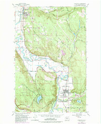
1953 Map of Carnation
USGS Topo · Published 1986About this map
The Snoqualmie River meanders through this portion of King County, defining a fertile valley floor dotted with agricultural landmarks and small rail-stop settlements. At the southern end, the town of Carnation serves as a local hub near the confluence with the Tolt River, featuring the Tolt High Sch and nearby Valley Memorial Park. The influence of large-scale agriculture is evident at the expansive Carnation Farm, situated along the riverbanks northwest of town.
Find a feature on this map
57 named features on this map. Tap any name to fly to it.
Don’t see what you’re looking for? This feature index may not catch every label — zoom into the map to look around manually.
Map Details
Editions of this 1953 Carnation Map
4 editions found

Other maps of this area

1895 · Snohomish
USGS Topo · 1:125,000

1897 · Seattle
USGS Topo · 1:125,000

1921 · Sultan
USGS Topo · 1:125,000

1923 · Sultan
USGS Topo · 1:125,000

1944 · Everett
USGS Topo · 1:62,500

1950 · Redmond
USGS Topo · 1:24,000

1950 · Issaquah
USGS Topo · 1:24,000

1953 · Snoqualmie
USGS Topo · 1:24,000

1953 · Sultan
USGS Topo · 1:24,000

1953 · Lake Joy
USGS Topo · 1:24,000