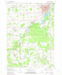
1963 Map of Caro
USGS Topo · Published 1980About this map
The Cass River serves as the geographic heart of this area, winding past the village of Wahjamega and the institutional grounds of the Caro State Hospital. This region reflects a mid-century balance between a growing county seat and expansive conservation lands. The town of Caro exhibits its roles as a local hub through features like the Fairground, High Sch, and the Sacred Heart Sch. To the south and west, the landscape transitions into the preserved wildlands of the Tuscola State Game Area and the Vassar State Game Area, where the terrain is dominated by a dense network of agricultural waterways such as the Washburn Drain and O'Brien Drain. Infrastructure from the era is well-represented by the New York Central railroad corridor and the Caro Airport, while local genealogy is rooted in sites like Indianfields Cemetery and Moreland Cem.
Find a feature on this map
93 named features on this map. Tap any name to fly to it.
Don’t see what you’re looking for? This feature index may not catch every label — zoom into the map to look around manually.
Map Details
Editions of this 1963 Caro Map
3 editions found
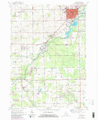
Other maps of this area

1954 · Flint
USGS Topo · 1:250,000

1958 · Flint
USGS Topo · 1:250,000

1963 · East Dayton
USGS Topo · 1:24,000

1963 · Mayville
USGS Topo · 1:24,000

1963 · Fairgrove
USGS Topo · 1:24,000

1963 · Ellington
USGS Topo · 1:24,000

1963 · Gilford
USGS Topo · 1:24,000

1963 · Caro
USGS Topo · 1:24,000

1963 · Vassar
USGS Topo · 1:24,000

1963 · Juniata
USGS Topo · 1:24,000