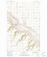
1949 Map of Carpio
USGS Topo · Published 1980About this map
The Carpio townsite serves as the central hub of this North Dakota landscape, situated where the Soo Line railroad cuts through the valley of the Des Lacs River. Surveyed in the late 1940s with later revisions, the map reveals a rural community supported by a network of drainage features and coulees, such as State Coulee, Johnson Coulee, and Oleas Coulee. This terrain is defined by the transition from the upland Plain and White Ash township areas down into the eroded river valley, where local commerce is represented by Gravel Pits and regional water management by Helseth Dam. Genealogists will find significant local landmarks, including the Nazareth Ch, Lutheran Cem, and St Johns Cem, alongside rural education sites like Helseth Sch and Skarbo Sch. The boundary between Renville County and Ward County is also clearly delineated.
Find a feature on this map
19 named features on this map. Tap any name to fly to it.
Don’t see what you’re looking for? This feature index may not catch every label — zoom into the map to look around manually.
Map Details
Editions of this 1949 Carpio Map
4 editions found
Other maps of this area

1947 · Tolley
USGS Topo · 1:62,500

1949 · Tolley SE
USGS Topo · 1:24,000

1949 · Hartland
USGS Topo · 1:24,000

1949 · Carpio NE
USGS Topo · 1:24,000

1949 · Carpio
USGS Topo · 1:24,000

1949 · Grano SW
USGS Topo · 1:24,000

1949 · Grano
USGS Topo · 1:24,000

1950 · Tolley
USGS Topo · 1:62,500

1950 · Des Lacs
USGS Topo · 1:24,000
1951 · Grano
USGS Topo · 1:62,500