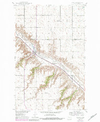
1949 Map of Carpio
USGS Topo · Published 1984About this map
The Carpio settlement serves as the central hub of this mid-century North Dakota landscape, situated where the Soo Line railroad and Route 52 intersect within the valley of the Des Lacs River. The terrain is defined by deep cuts into the prairie, including Hansen Coulee, Egg Coulee, and Hartland Coulee, which create a complex drainage system across the townships of White Ash and Maryland.
Find a feature on this map
18 named features on this map. Tap any name to fly to it.
Don’t see what you’re looking for? This feature index may not catch every label — zoom into the map to look around manually.
Map Details
Editions of this 1949 Carpio Map
4 editions found
Other maps of this area

1947 · Tolley
USGS Topo · 1:62,500

1949 · Tolley SE
USGS Topo · 1:24,000

1949 · Hartland
USGS Topo · 1:24,000

1949 · Carpio NE
USGS Topo · 1:24,000

1949 · Carpio
USGS Topo · 1:24,000

1949 · Grano SW
USGS Topo · 1:24,000

1949 · Grano
USGS Topo · 1:24,000

1950 · Tolley
USGS Topo · 1:62,500

1950 · Des Lacs
USGS Topo · 1:24,000
1951 · Grano
USGS Topo · 1:62,500