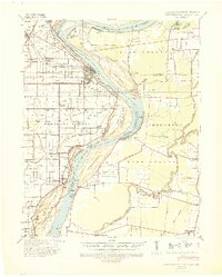
1939 Map of Caruthersville
USGS Topo · Published 1943About this map
Caruthersville sits at a critical bend of the Mississippi River, where the complex hydrology of the Bootheel is on full display before the mid-century's massive flood control changes. This 1939 survey records a landscape defined by its relation to the water, from the Little Prairie Bend to the numerous islands like Island No 18 and Island No 20. The map documents a dense network of rural infrastructure, including namesake schools like McCarty Sch and Needmore Sch, which served the farming and timber communities along the riverbanks. The industrial footprint of the era is evident in settlements like Mengelwood and Band Mill in Tennessee, while the St Louis Southwestern railroad provides the primary overland connection through Hayti and Carlston. The detailed recording of revetments, retards, and dikes along Linwood Bend illustrates the ongoing struggle to stabilize this volatile stretch of the river.
Find a feature on this map
65 named features on this map. Tap any name to fly to it.
Don’t see what you’re looking for? This feature index may not catch every label — zoom into the map to look around manually.
Map Details
Editions of this 1939 Caruthersville Map
2 editions found
Other maps of this area

1925 · Reelfoot Lake
USGS Topo · 1:62,500

1939 · Reelfoot Lake
USGS Topo · 1:62,500

1939 · Portageville
USGS Topo · 1:62,500

1939 · Dyersburg
USGS Topo · 1:62,500

1939 · Hales Point
USGS Topo · 1:62,500

1939 · Caruthersville
USGS Topo · 1:62,500

1939 · Halls
USGS Topo · 1:62,500

1939 · Blytheville
USGS Topo · 1:62,500

1940 · Pascola
USGS Topo · 1:62,500

1940 · Hayti
USGS Topo · 1:62,500