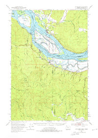
1953 Map of Cathlamet
USGS Topo · Published 1976About this map
Cathlamet serves as the focal point for this riverside survey, situated where the Columbia River splits into a complex network of channels and sloughs. This era reveals a landscape defined by its waterways and islands, including Tenasillahe Island and the Hunting Islands, where levees and sloughs like Bernie Slough and Welcome Slough dictate the movement of goods and people. Along the Oregon shore, the Spokane Portland and Seattle railroad follows the riverbank, connecting industrial and residential outposts such as Bradwood and Clifton.
Find a feature on this map
65 named features on this map. Tap any name to fly to it.
Don’t see what you’re looking for? This feature index may not catch every label — zoom into the map to look around manually.
Map Details
Editions of this 1953 Cathlamet Map
4 editions found

Other maps of this area

1919 · Mayger
USGS Topo · 1:62,500

1939 · Saddle Mountain
USGS Topo · 1:62,500

1940 · Svensen
USGS Topo · 1:62,500

1940 · Brookfield
USGS Topo · 1:62,500

1940 · Vernonia
USGS Topo · 1:62,500

1941 · Keasey
USGS Topo · 1:62,500

1941 · Skamokawa
USGS Topo · 1:62,500

1941 · Clatskanie
USGS Topo · 1:62,500

1941 · Cathlamet
USGS Topo · 1:62,500

1943 · Vernonia
USGS Topo · 1:62,500