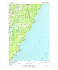
1963 Map of Cedar River
USGS Topo · Published 1979About this map
Cedar River flows through the heart of the Upper Peninsula's shoreline in this mid-century topographic record, where the waters of Green Bay meet the sprawling timberlands of the Cedarville State Forest. The map captures a coastal landscape defined by small maritime and forest-edge settlements such as Walton and Ruleau, alongside the distinct religious site of the Dominican House of Studies near Hayward Bay. The shoreline itself is a series of named landforms and recreational developments, from the dangerous connotations of Deadmans Point to the public grounds of J W Wells State Park and Kleinke Park. To the south, Johnson Landing and the inland settlement of Johnson suggest small communities tied to the lake. The terrain is dotted with numerous small water bodies like Westman Lake and Richardt Lake, revealing a complex drainage system of marshes and creeks that supported the regional economy and natural character of Menominee County.
Find a feature on this map
47 named features on this map. Tap any name to fly to it.
Don’t see what you’re looking for? This feature index may not catch every label — zoom into the map to look around manually.
Map Details
Editions of this 1963 Cedar River Map
3 editions found

Other maps of this area

1939 · Marinette
USGS Topo · 1:48,000

1949 · Stephenson
USGS Topo · 1:48,000

1954 · Escanaba
USGS Topo · 1:250,000

1957 · Escanaba
USGS Topo · 1:250,000

1958 · Escanaba
USGS Topo · 1:250,000

1958 · Escanaba
USGS Topo · 1:62,500

1960 · Sister Bay
USGS Topo · 1:62,500

1960 · Ellison Bay
USGS Topo · 1:62,500

1961 · Chambers Island
USGS Topo · 1:62,500

1963 · Bark River
USGS Topo · 1:62,500
Featured Places
- Ingallston Township, MI
- Beach Grove, MI
- Cedarville Township, MI
- Daggett Township, MI
- Johnson Landing, MI