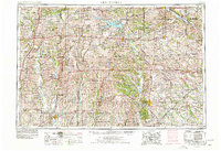
1954 Map of Centerville
USGS Topo · Published 1978About this map
The Iowa Missouri borderlands center on the expansive Rathbun Reservoir and the commercial hub of Centerville during the mid-1970s. This survey, updated from 1950s data with mid-century aerial photography, shows a landscape defined by its river systems and recreational developments. Notable water bodies like Lake Wapello and Red Haw Lake are anchored by state parks such as Honey Creek State Park and Lacey Keosauqua State Park, indicating the region's mid-century shift toward land conservation.
Find a feature on this map
152 named features on this map. Tap any name to fly to it.
Don’t see what you’re looking for? This feature index may not catch every label — zoom into the map to look around manually.
Map Details
Editions of this 1954 Centerville Map
3 editions found

Other maps of this area

1903 · Kahoka
USGS Topo · 1:125,000

1903 · Palmyra
USGS Topo · 1:125,000

1903 · Edina
USGS Topo · 1:125,000

1908 · Atlanta
USGS Topo · 1:62,500

1911 · Queen City
USGS Topo · 1:62,500

1912 · Green City
USGS Topo · 1:62,500

1913 · Queen City
USGS Topo · 1:62,500

1914 · Green City
USGS Topo · 1:62,500

1918 · Chariton
USGS Topo · 1:62,500

1921 · Chillicothe
USGS Topo · 1:62,500