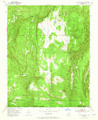
1953 Map of Cerro Del Grant
USGS Topo · Published 1965About this map
Santa Fe National Forest landscapes in the early 1950s are defined by high-altitude ranching and timber extraction at the boundary of the Polvadera Grant and Baca Location No 1. The map documents a transition in local industry, showing the active Mascara es Sawmill in the north and the Upper Coyote Creek Sawmill (Aband) to the south, reflecting the movement of logging operations through these drainages. Central to the sheet is the expansive Valle de la Grulla, where the La Grulla Ranch sits near Laguna de la Grulla. The terrain is marked by prominent peaks such as Cerro Valdez and Cerro del Grant, while an network of tracks like the Lookout Road and Pack Trail connect isolated points like the Encino Lookout to the creek valleys below.
Find a feature on this map
49 named features on this map. Tap any name to fly to it.
Don’t see what you’re looking for? This feature index may not catch every label — zoom into the map to look around manually.
Map Details
Editions of this 1953 Cerro Del Grant Map
3 editions found

Other maps of this area

1890 · Jemes
USGS Topo · 1:125,000

1892 · Jemes
USGS Topo · 1:125,000

1892 · Santa Clara
USGS Topo · 1:125,000

1909 · Gallina
USGS Topo · 1:125,000

1918 · Abiquiu
USGS Topo · 1:125,000

1937 · Jemez Springs
USGS Topo · 1:48,000

1944 · Jemez Springs
USGS Topo · 1:62,500

1952 · Valle Toledo
USGS Topo · 1:24,000

1952 · Jemez Springs
USGS Topo · 1:62,500

1953 · Canones
USGS Topo · 1:24,000