
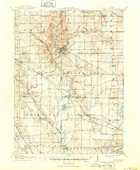
1908 Map of Chagrin Falls
USGS Topo · Published 1939About this map
Chagrin Falls serves as the focal point of this 1905–1906 survey, where the Chagrin River carves through the terrain of Cuyahoga and Geauga counties. At the start of the twentieth century, this region was a complex network of transit, featuring the Cleveland and Garrettsville Electric RR alongside traditional steam lines like the Wheeling and Lake Erie. The landscape is dotted with small rural hubs and post offices such as Falls Junction Glenwillow PO and Moran Jesse PO, reflecting a period when postal identity was tied to specific rail junctions and local centers.
Find a feature on this map
58 named features on this map. Tap any name to fly to it.
Don’t see what you’re looking for? This feature index may not catch every label — zoom into the map to look around manually.
Map Details
Editions of this 1908 Chagrin Falls Map
2 editions found
Other maps of this area

1901 · Euclid
USGS Topo · 1:62,500

1903 · Cleveland
USGS Topo · 1:62,500

1903 · Euclid
USGS Topo · 1:62,500

1903 · Akron
USGS Topo · 1:62,500

1904 · Chardon
USGS Topo · 1:62,500

1905 · Akron
USGS Topo · 1:62,500

1905 · Garrettsville
USGS Topo · 1:62,500

1905 · Mentor
USGS Topo · 1:62,500

1906 · Chardon
USGS Topo · 1:62,500

1906 · Kent
USGS Topo · 1:62,500