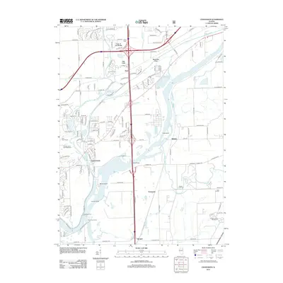
2012 Map of Channahon
USGS Topo · Published 2012About this map
The Des Plaines River and DuPage River converge in this industrial and residential landscape southwest of Joliet. The village of Channahon sits at this confluence, surrounded by a complex network of river islands such as Moose Island and Conroy Island. The area reflects a mix of modern infrastructure and agricultural heritage, shown by the Hadley Seed Farm and the specialized aviation facilities at Aero Four Airport and the Chicago Glider Club Gliderport. To the east, the sprawling grounds of the Abraham Lincoln National Cem dominate the terrain near Blodgett. The map also details several smaller residential developments like Lake of the Woods and Oak Lane, alongside the river-adjacent locations of Millsdale and Drummond. Local history is preserved in sites like Jackson Creek Cem and Maple Hill Cem, which stand in contrast to the heavy transport corridors of the interstate and frontage roads.
Find a feature on this map
95 named features on this map. Tap any name to fly to it.
Don’t see what you’re looking for? This feature index may not catch every label — zoom into the map to look around manually.
Map Details
Editions of this 2012 Channahon Map
This is the sole edition of this map. No revisions or reprints were ever made.
Other maps of this area

1892 · Morris
USGS Topo · 1:62,500

1892 · Joliet
USGS Topo · 1:62,500

1892 · Wilmington
USGS Topo · 1:62,500

1918 · Wilmington
USGS Topo · 1:62,500

1918 · Morris
USGS Topo · 1:62,500

1923 · Joliet
USGS Topo · 1:62,500

1925 · Yorkville
USGS Topo · 1:62,500

1953 · Yorkville SE
USGS Topo · 1:24,000

1953 · Coal City
USGS Topo · 1:24,000

1953 · Symerton
USGS Topo · 1:24,000