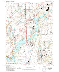
1993 Map of Channahon
USGS Topo · Published 1994About this map
Industrial corridors and conservation lands intersect at the confluence of the Du Page River and the Des Plaines River in this early 1990s survey. The landscape is defined by its strategic position between Joliet and Minooka, dominated by the massive footprint of the Joliet Ammunitions Plant in the southeast. This sprawling facility stands in contrast to the preserved natural and recreational spaces nearby, including the Channahon Parkway State Park and the McKinley Woods Co Forest Preserve.
Find a feature on this map
54 named features on this map. Tap any name to fly to it.
Don’t see what you’re looking for? This feature index may not catch every label — zoom into the map to look around manually.
Map Details
Editions of this 1993 Channahon Map
This is the sole edition of this map. No revisions or reprints were ever made.
Other maps of this area

1892 · Morris
USGS Topo · 1:62,500

1892 · Joliet
USGS Topo · 1:62,500

1892 · Wilmington
USGS Topo · 1:62,500

1918 · Wilmington
USGS Topo · 1:62,500

1918 · Morris
USGS Topo · 1:62,500

1923 · Joliet
USGS Topo · 1:62,500

1925 · Yorkville
USGS Topo · 1:62,500

1953 · Yorkville SE
USGS Topo · 1:24,000

1953 · Coal City
USGS Topo · 1:24,000

1953 · Symerton
USGS Topo · 1:24,000