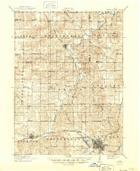
1918 Map of Chariton
USGS Topo · Published 1949About this map
Chariton serves as the regional hub at the southeastern edge of this landscape, where the Chicago Burlington And Quincy rail lines converge near Crystal Lake. The surrounding terrain is a detailed network of small agricultural townships, including Liberty, Whitebreast, and English, each defined by a dense distribution of rural institutions. This early 20th-century survey documents an era before school consolidation, preserving the exact locations of dozens of neighborhood schoolhouses such as Horstman School, Dallas Center School, and Cackler School.
Find a feature on this map
75 named features on this map. Tap any name to fly to it.
Don’t see what you’re looking for? This feature index may not catch every label — zoom into the map to look around manually.
Map Details
Editions of this 1918 Chariton Map
4 editions found
Other maps of this area

1909 · Knoxville
USGS Topo · 1:62,500

1910 · Milo
USGS Topo · 1:62,500

1912 · Knoxville
USGS Topo · 1:62,500

1918 · Chariton
USGS Topo · 1:62,500

1924 · Melcher
USGS Topo · 1:62,500

1931 · Indianola
USGS Topo · 1:62,500

1934 · Humeston
USGS Topo · 1:48,000

1935 · Russell
USGS Topo · 1:62,500

1937 · Corydon
USGS Topo · 1:62,500

1938 · Russell
USGS Topo · 1:62,500