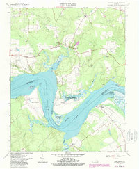
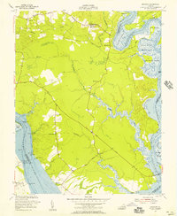
1965 Map of Charles City
USGS Topo · Published 1987About this map
James River plantations and historic Tidewater settlements dominate this mid-century survey of the Virginia Peninsula. The landscape is defined by the deep reach of the river and its many winding tributaries, including Kittewan Creek, Mapsico Creek, and Tyler Creek. On the southern bank, the prominent bend of the Three Mile Reach passes the legendary grounds of Flowerdew Hundred and Upper Brandon, while the northern shore features Sherwood Forest and the landing at Willcox Wharf. The transition from riverine commerce to an inland agricultural economy is evident in the cluster of small communities and crossroads like Ruthville, Charles City, and New Hope. Significant landmarks from different eras of Virginia history appear side-by-side, from the site of Fort Powhatan overlooking the water to the conserved lands of the Kittewan State Wildlife Refuge.
Find a feature on this map
52 named features on this map. Tap any name to fly to it.
Don’t see what you’re looking for? This feature index may not catch every label — zoom into the map to look around manually.
Map Details
Editions of this 1965 Charles City Map
4 editions found
Other maps of this area

1917 · Toano
USGS Topo · 1:62,500

1918 · Charles City
USGS Topo · 1:62,500

1918 · Toano
USGS Topo · 1:62,500

1919 · Surry
USGS Topo · 1:62,500

1919 · Disputanta
USGS Topo · 1:62,500

1943 · Savedge
USGS Topo · 1:31,680

1943 · Disputanta
USGS Topo · 1:31,680

1943 · Richmond
USGS Topo · 1:250,000

1949 · Richmond
USGS Topo · 1:250,000
1952 · Brandon
USGS Topo · 1:24,000