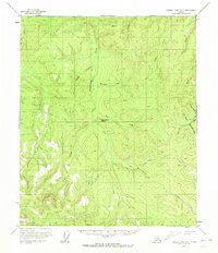
1956 Map of Charley River A-3
USGS Topo · Published 1972About this map
Strawberry Dome and the surrounding drainages of the Charley River headwaters reveal an active gold-mining landscape as it existed in the mid-1950s. The presence of a Placer Mine near Fourth of July Creek, alongside a network of gulches including Butte Gulch, Owl Gulch, and Seventeen Gulch, points to a long history of mineral exploration in this part of the Yukon-Tanana Uplands. The terrain is characterized by a series of high ridges and deep valleys carved by Washington Creek, Eagle Creek, and Surprise Creek. A notable Ditch and a Tractor Trail cutting across the southern sections illustrate the infrastructure required for remote extraction. Isolated landmarks such as the Pingo formations and high surveying points like VABM 2452 Glenn provide specific geographic anchors for those studying the physical evolution of this interior wilderness.
Find a feature on this map
24 named features on this map. Tap any name to fly to it.
Don’t see what you’re looking for? This feature index may not catch every label — zoom into the map to look around manually.
Map Details
Editions of this 1956 Charley River A-3 Map
2 editions found
Other maps of this area

1899 · Fortymile
USGS Topo · 1:250,000

1951 · Charley River
USGS Topo · 1:250,000

1951 · Eagle
USGS Topo · 1:250,000

1956 · Charley River A-4
USGS Topo · 1:63,360

1956 · Charley River B-3
USGS Topo · 1:63,360

1956 · Charley River B-2
USGS Topo · 1:63,360

1956 · Charley River A-3
USGS Topo · 1:63,360

1956 · Charley River A-2
USGS Topo · 1:63,360

1956 · Charley River B-4
USGS Topo · 1:63,360

1956 · Charley River
USGS Topo · 1:250,000