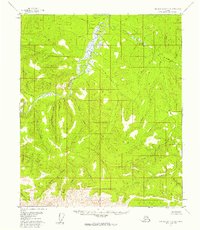
1956 Map of Charley River A-4
USGS Topo · Published 1960About this map
The Charley River meanders through this interior Alaskan wilderness, serving as the central drainage for a complex network of tributaries such as Cultas Creek and Silvia Creek. Surveyed in the mid-1950s, the terrain is characterized by high ridges and deep valleys, evidenced by the numerous named watercourses that flow from the highlands toward the river basin. To the east, Fisher Creek and Derwent Creek drain the slopes near the unusual geological feature identified as a Pingo, a frost-heaved mound indicative of the region's permafrost environment. The southern portion of the map is defined by the steep rises of the Ogilvie Mountains, where Marks Creek and Highland Creek originate. This map documents a landscape before significant human development, highlighting the natural hydrological patterns of the Yukon-Charley region including Uncompahgre Creek and the remote Boston Gulch.
Find a feature on this map
21 named features on this map. Tap any name to fly to it.
Don’t see what you’re looking for? This feature index may not catch every label — zoom into the map to look around manually.
Map Details
Editions of this 1956 Charley River A-4 Map
2 editions found
Other maps of this area

1951 · Charley River
USGS Topo · 1:250,000

1951 · Eagle
USGS Topo · 1:250,000

1956 · Charley River A-5
USGS Topo · 1:63,360

1956 · Charley River A-4
USGS Topo · 1:63,360

1956 · Charley River B-5
USGS Topo · 1:63,360

1956 · Charley River B-3
USGS Topo · 1:63,360

1956 · Charley River A-3
USGS Topo · 1:63,360

1956 · Charley River B-4
USGS Topo · 1:63,360

1956 · Charley River
USGS Topo · 1:250,000

1956 · Eagle D-3
USGS Topo · 1:63,360