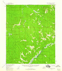
1956 Map of Charley River D-1
USGS Topo · Published 1960About this map
The United States Canada international boundary marks the eastern edge of this 1950s interior Alaskan landscape, where the terrain is defined by the winding course of the Charley River. This remote subarctic environment exhibits fascinating periglacial geomorphology, specifically the presence of Pingos and individual Pingo formations—ice-cored mounds that rise from the swampy lowlands. These features indicate a landscape of discontinuous permafrost and significant hydrological activity in the valley floors. Waterways like Bull Creek and Midnight Creek drain the surrounding uplands, feeding into the main river system. The map reflects a period of systematic aerial photogrammetric surveying by the Geological Survey, capturing a transition zone where the Alaska Yukon border meets the vast, uninhabited stretches of the Fairbanks Meridian.
Find a feature on this map
7 named features on this map. Tap any name to fly to it.
Don’t see what you’re looking for? This feature index may not catch every label — zoom into the map to look around manually.
Map Details
Editions of this 1956 Charley River D-1 Map
2 editions found
Other maps of this area

1951 · Charley River
USGS Topo · 1:250,000

1951 · Black River
USGS Topo · 1:250,000
1956 · Black River A-1
USGS Topo · 1:63,360

1956 · Black River A-2
USGS Topo · 1:63,360

1956 · Charley River C-2
USGS Topo · 1:63,360
1956 · Charley River C-1
USGS Topo · 1:63,360

1956 · Black River
USGS Topo · 1:250,000

1956 · Charley River D-2
USGS Topo · 1:63,360

1956 · Charley River
USGS Topo · 1:250,000

1964 · Black River
USGS Topo · 1:250,000