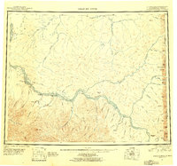
1951 Map of Charley River
USGS Topo · Published 1956About this map
Yukon River waters dominate this mid-century reconnaissance, flowing past remote outposts and early industrial sites along the Alaska Yukon border. The map documents a landscape where traditional river travel met localized mining activity, evidenced by the Tailings and Landing Area near Woodchopper and Coal Creek. Settlement patterns are sparse, defined by isolated structures simply labeled Cabin and more established sites like the now-quiet Millers Camp (Aban'd) near the Tatonduk River. Navigation and land management are anchored by numerous survey monuments and bench marks, such as VABM 4132 Pack, while the terrain is marked by distinctive heights like Kathul Mtn and Indian Grave Mtn. This survey provides an essential view of the eastern interior's geography before significant modern development, preserving the locations of Nation Landing Area and the long Ditch systems used in hydraulic mining operations.
Find a feature on this map
78 named features on this map. Tap any name to fly to it.
Don’t see what you’re looking for? This feature index may not catch every label — zoom into the map to look around manually.
Map Details
Editions of this 1951 Charley River Map
5 editions found
Other maps of this area

1899 · Fortymile
USGS Topo · 1:250,000

1950 · Big Delta
USGS Topo · 1:250,000

1951 · Big Delta
USGS Topo · 1:250,000

1951 · Fort Yukon
USGS Topo · 1:250,000

1951 · Charley River
USGS Topo · 1:250,000

1951 · Eagle
USGS Topo · 1:250,000

1951 · Black River
USGS Topo · 1:250,000

1951 · Circle
USGS Topo · 1:250,000

1955 · Circle A-1
USGS Topo · 1:63,360

1955 · Circle B-1
USGS Topo · 1:63,360