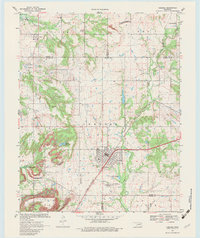
1970 Map of Chelsea
USGS Topo · Published 1983About this map
Chelsea serves as the primary hub in this corner of Northeast Oklahoma, where the St Louis-San Francisco railroad bisects the town diagonally. The landscape is defined by extensive industrial and agricultural patterns, most notably the numerous Strip Mines and Oil Wells that dot the terrain between the Rogers, Nowata, and Craig county lines. Water management is a significant feature of the area, evidenced by the large Oologah Lake in the northwest and Chelsea Reservoir to the southwest, both of which altered the local drainage of Panther Creek and Spencer Creek.
Find a feature on this map
36 named features on this map. Tap any name to fly to it.
Don’t see what you’re looking for? This feature index may not catch every label — zoom into the map to look around manually.
Map Details
Editions of this 1970 Chelsea Map
3 editions found

Other maps of this area

1896 · Pryor
USGS Topo · 1:125,000

1901 · Claremore
USGS Topo · 1:125,000

1901 · Nowata
USGS Topo · 1:125,000

1901 · Vinita
USGS Topo · 1:125,000

1901 · Pryor
USGS Topo · 1:125,000

1913 · Vinita
USGS Topo · 1:125,000

1914 · Nowata
USGS Topo · 1:125,000

1914 · Claremore
USGS Topo · 1:125,000

1916 · Claremore
USGS Topo · 1:125,000

1954 · Tulsa
USGS Topo · 1:250,000