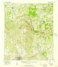
1956 Map of Cherokee
USGS Topo · Published 1957About this map
The Llano River and its tributary, the Little Llano River, anchor this mid-1950s survey of the Central Texas hill country. In the southern portion, the town of Llano is a central hub of activity, featuring the Llano City Lake and the Texas and New Orleans (Southern Pacific) railroad line. Further north, the settlement of Babyhead shows signs of transition with its Babyhead Ch (Aband) and Babyhead Sch (Aband) labeled as abandoned, though the Babyhead Cem remains a fixed point of local history. Notable granite and limestone landforms like Marley Peaks and Babyhead Mountain rise above the drainage basins of Cherokee Creek and Pecan Creek. The landscape reflects a mix of ranching and early industrial sites, including a Quarry and Gravel Pit near Lone Grove, alongside the developing infrastructure of the Llano County Airport.
Find a feature on this map
56 named features on this map. Tap any name to fly to it.
Don’t see what you’re looking for? This feature index may not catch every label — zoom into the map to look around manually.
Map Details
Editions of this 1956 Cherokee Map
This is the sole edition of this map. No revisions or reprints were ever made.
Other maps of this area

1885 · San Saba
USGS Topo · 1:125,000

1887 · Llano
USGS Topo · 1:125,000

1887 · Lampasas
USGS Topo · 1:125,000

1887 · Burnet
USGS Topo · 1:125,000

1893 · Burnet
USGS Topo · 1:125,000

1894 · Lampasas
USGS Topo · 1:125,000

1894 · San Saba
USGS Topo · 1:125,000

1894 · Llano
USGS Topo · 1:125,000

1903 · Burnet
USGS Topo · 1:125,000

1904 · Llano
USGS Topo · 1:125,000