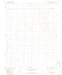
1982 Map of Cheyenne Wells 3 SW
USGS Topo · Published 1982About this map
Cheyenne Co and Kiowa Co meet in this high plains landscape of eastern Colorado, defined by a sparse network of energy and transport infrastructure. The map depicts a period of modern resource extraction and utility expansion, evidenced by the presence of an Oil Well and a Pipeline cutting across the survey area. The terrain is largely dominated by the drainage of Big Sandy Creek, which winds through the southern portion of the sheet. Industrial and navigational landmarks are few but significant for local history, including several Gravel Pits and a dedicated Landing Strip in the northern sections. This 1982 edition reflects the utilitarian character of the region, where wide-open spaces are punctuated by technical markers like a water Tank and scattered Wells, serving as critical points of reference in an otherwise open environment.
Find a feature on this map
8 named features on this map. Tap any name to fly to it.
Don’t see what you’re looking for? This feature index may not catch every label — zoom into the map to look around manually.
Map Details
Editions of this 1982 Cheyenne Wells 3 SW Map
2 editions found
Other maps of this area

1890 · Granada
USGS Topo · 1:125,000

1891 · Kit Carson
USGS Topo · 1:125,000

1892 · Lamar
USGS Topo · 1:125,000

1892 · Cheyenne Wells
USGS Topo · 1:125,000

1892 · Granada
USGS Topo · 1:125,000

1893 · Kit Carson
USGS Topo · 1:125,000

1894 · Cheyenne Wells
USGS Topo · 1:125,000

1894 · Granada
USGS Topo · 1:125,000

1954 · Lamar
USGS Topo · 1:250,000

1958 · Lamar
USGS Topo · 1:250,000