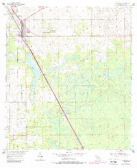
1954 Map of Chiefland
USGS Topo · Published 1988About this map
Chiefland and its surrounding rural landscapes are documented here during a period of transition, showing the town at the intersection of evolving transportation corridors. The layout reveals a high density of country churches and community burial grounds, such as Mt Pleasant Ch, Morning Star Ch, and the Adamsville Cem, reflecting the deep-rooted social and family structures of the area. Just south of the primary settlement, Long Pond stretches through the terrain, while the Old Railroad Grade serves as a reminder of earlier logging or transit routes that once defined the local economy. Further south, the map identifies small clusters like Usher and Hardeetown, alongside local landmarks including a Lookout Tower and several outlying cemeteries like Levyville Cem and Galilee Cem, which provide essential points of reference for genealogical research and local history studies.
Find a feature on this map
16 named features on this map. Tap any name to fly to it.
Don’t see what you’re looking for? This feature index may not catch every label — zoom into the map to look around manually.
Map Details
Editions of this 1954 Chiefland Map
4 editions found
Other maps of this area

1954 · Chiefland
USGS Topo · 1:24,000

1954 · Otter Creek
USGS Topo · 1:24,000

1954 · Bronson
USGS Topo · 1:24,000

1954 · Manatee Springs
USGS Topo · 1:24,000

1954 · Chiefland SW
USGS Topo · 1:24,000

1954 · Bronson SW
USGS Topo · 1:24,000

1954 · Gainesville
USGS Topo · 1:250,000

1958 · Gainesville
USGS Topo · 1:250,000

1959 · Gainesville
USGS Topo · 1:250,000

1968 · Newberry SW
USGS Topo · 1:24,000