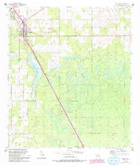
1954 Map of Chiefland
USGS Topo · Published 1993About this map
Chiefland sits at the junction of several rural routes in north-central Florida, surrounded by a landscape defined by scattered cypress ponds and small farming communities. The 1950s era of this survey shows the town's expansion toward Hardee-town to the northwest, while the southern reaches remain dominated by the elongated waters of Long Pond. A network of country churches serves the outlying districts, including St Johns Ch, Mt Bethel Ch, and Morning Star Ch, reflecting the deep-rooted social fabric of the county. The transition in transportation is evident along the Old Railroad Grade, which parallels the modern roads leading toward the settlement at Usher. Local family histories are preserved in several documented burial grounds, such as Adamsville Cem and Levyville Cem, providing valuable points of interest for genealogical research in this part of Levy County.
Find a feature on this map
17 named features on this map. Tap any name to fly to it.
Don’t see what you’re looking for? This feature index may not catch every label — zoom into the map to look around manually.
Map Details
Editions of this 1954 Chiefland Map
4 editions found
Other maps of this area

1954 · Chiefland
USGS Topo · 1:24,000

1954 · Otter Creek
USGS Topo · 1:24,000

1954 · Bronson
USGS Topo · 1:24,000

1954 · Manatee Springs
USGS Topo · 1:24,000

1954 · Chiefland SW
USGS Topo · 1:24,000

1954 · Bronson SW
USGS Topo · 1:24,000

1954 · Gainesville
USGS Topo · 1:250,000

1958 · Gainesville
USGS Topo · 1:250,000

1959 · Gainesville
USGS Topo · 1:250,000

1968 · Newberry SW
USGS Topo · 1:24,000