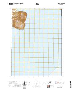
2020 Map of Chignik B-1 NE
USGS Topo · Published 2020About this map
Weasel Mtn rises above the coastline of the Alaska Peninsula in this survey of the Lake and Peninsula Borough. The terrain is defined by the sharp transition from the elevated peaks of the Aleutian Range down to the tidal waters of Hook Bay and Cape Kumliun. These coastal landmarks serve as critical navigational points along the northern edge of the Gulf of Alaska. The landscape here is characterized by its isolation, with the U.S. Geological Survey mapping a region where natural features dictate the boundaries of the Public Land Survey System, as seen in the large township and range blocks like t42s r56w. The map provides a detailed topographic view of the shoreline and the dramatic elevation shifts typical of this remote maritime environment.
Find a feature on this map
9 named features on this map. Tap any name to fly to it.
Don’t see what you’re looking for? This feature index may not catch every label — zoom into the map to look around manually.
Map Details
Editions of this 2020 Chignik B-1 NE Map
This is the sole edition of this map. No revisions or reprints were ever made.
Other maps of this area

1951 · Sutwik Island
USGS Topo · 1:250,000

1963 · Chignik B-1
USGS Topo · 1:63,360

1963 · Chignik C-1
USGS Topo · 1:63,360

1963 · Sutwik Island B-6
USGS Topo · 1:63,360

1963 · Sutwik Island
USGS Topo · 1:250,000

1963 · Sutwik Island C-6
USGS Topo · 1:63,360

1963 · Chignik
USGS Topo · 1:250,000
2019 · Sutwik Island B-6 NW
USGS Topo · 1:25,000
2019 · Sutwik Island B-6 SW
USGS Topo · 1:25,000
2019 · Sutwik Island C-6 SW
USGS Topo · 1:25,000