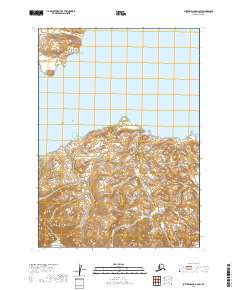
2019 Map of Sutwik Island C-6 SW
USGS Topo · Published 2019About this map
Cape Kumliun dominates this coastal survey, forming a prominent divide between the waters of Kujulik Bay to the north and Chignik Bay to the south. This rugged stretch of the Alaska Peninsula is defined by sharp topographic shifts where coastal drainages like Kumliun Cr cut through the landscape toward the Pacific. The map provides a high-resolution view of the shoreline and elevation contours as they existed in the early twenty-first century, capturing a region where the land meets the sea without the infrastructure of modern roads or settlements. The survey focus remains on the natural geography and the maritime boundary of the Alaska-Lake and Peninsula Borough, reflecting the untouched character of these remote coastal waters.
Find a feature on this map
8 named features on this map. Tap any name to fly to it.
Don’t see what you’re looking for? This feature index may not catch every label — zoom into the map to look around manually.
Map Details
Editions of this 2019 Sutwik Island C-6 SW Map
This is the sole edition of this map. No revisions or reprints were ever made.
Other maps of this area

1951 · Sutwik Island
USGS Topo · 1:250,000

1963 · Chignik B-1
USGS Topo · 1:63,360

1963 · Chignik C-1
USGS Topo · 1:63,360

1963 · Sutwik Island B-6
USGS Topo · 1:63,360

1963 · Sutwik Island
USGS Topo · 1:250,000

1963 · Sutwik Island C-6
USGS Topo · 1:63,360

1963 · Chignik
USGS Topo · 1:250,000
2019 · Sutwik Island B-6 NW
USGS Topo · 1:25,000
2019 · Sutwik Island B-6 NE
USGS Topo · 1:25,000
2019 · Sutwik Island C-6 NW
USGS Topo · 1:25,000