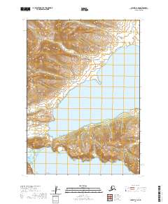
2020 Map of Chignik C-1 SE
USGS Topo · Published 2020About this map
The Aleutian Range dominates the western half of this maritime landscape, where steep coastal mountains drop sharply into the North Pacific. This survey captures a rugged section of the Alaska Peninsula defined by deep indentations of the sea, most notably the wide expanse of Kujulik Bay and the northern reaches of Chignik Bay. The geography is shaped by dramatic elevation changes, from sea level up through the narrow Black Pass, providing a clear record of the area's complex drainage systems. Several freshwater sources, including Bear Cr and Hook Creek, flow from the interior heights toward the tidal flats. Notable landmarks such as Cape Kumliun serve as critical navigational points along this wilderness coastline, illustrating the interaction between the peninsula's mountainous spine and the surrounding bays.
Find a feature on this map
15 named features on this map. Tap any name to fly to it.
Don’t see what you’re looking for? This feature index may not catch every label — zoom into the map to look around manually.
Map Details
Editions of this 2020 Chignik C-1 SE Map
This is the sole edition of this map. No revisions or reprints were ever made.
Other maps of this area

1951 · Sutwik Island
USGS Topo · 1:250,000

1963 · Chignik B-1
USGS Topo · 1:63,360

1963 · Chignik C-1
USGS Topo · 1:63,360

1963 · Sutwik Island B-6
USGS Topo · 1:63,360

1963 · Sutwik Island
USGS Topo · 1:250,000

1963 · Sutwik Island C-6
USGS Topo · 1:63,360

1963 · Chignik
USGS Topo · 1:250,000
2019 · Sutwik Island B-6 NW
USGS Topo · 1:25,000
2019 · Sutwik Island C-6 NW
USGS Topo · 1:25,000
2019 · Sutwik Island C-6 SW
USGS Topo · 1:25,000