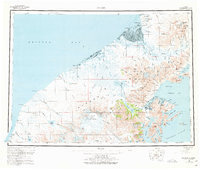
1963 Map of Chignik
USGS Topo · Published 1977About this map
Mount Veniaminof dominates the central landscape of this section of the Alaska Peninsula, its glacial system feeding numerous rivers that flow toward both Bristol Bay and the Pacific Ocean. On the northern coast, the settlement of Port Heiden sits near Strogonof Pt and the Port Heiden Airfield, serving as a remote outpost along the marshy reaches of the Meshik River. To the southeast, the geography shifts to the jagged coastline of Chignik Bay, where fishing communities like Chignik and Chignik Lagoon are tucked into protected harbors. The map reveals a complex network of internal waterways, including Chignik Lake and Black Lake, which are linked to the coast by the Chignik River. These inland waters and the surrounding peaks of the Aleutian Range, such as Knife Peak, define a region shaped by extreme volcanic topography and coastal maritime activity.
Find a feature on this map
134 named features on this map. Tap any name to fly to it.
Don’t see what you’re looking for? This feature index may not catch every label — zoom into the map to look around manually.
Map Details
Editions of this 1963 Chignik Map
3 editions found

Other maps of this area

1943 · Ugashik
USGS Topo · 1:250,000

1948 · Ugashik
USGS Topo · 1:250,000

1949 · Ugashik
USGS Topo · 1:250,000

1951 · Bristol Bay
USGS Topo · 1:250,000

1951 · Stepovak Bay
USGS Topo · 1:250,000

1951 · Sutwik Island
USGS Topo · 1:250,000

1953 · Port Moller
USGS Topo · 1:250,000

1963 · Stepovak Bay D-2
USGS Topo · 1:63,360

1963 · Chignik B-2
USGS Topo · 1:63,360

1963 · Chignik C-3
USGS Topo · 1:63,360