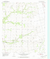
1952 Map of China Grove
USGS Topo · Published 1977About this map
China Grove and the surrounding high plains of West Texas are depicted here shortly after the mid-century, reflecting a landscape defined by ranching and early petroleum infrastructure. The rural character of the region is punctuated by the presence of China Grove Sch and German Sch, indicating the historical community centers of this sparsely populated area. Water management and livestock operations are evident through the numerous Windmill labels scattered across the terrain near Sulphur Creek and Wildcat Draw. The local economy's shift is marked by the Roscoe Snyder and Pacific railroad in the northeast corner and clusters of Oil Storage Tanks and a Radio Tower, showing the technical expansion into Scurry and Mitchell counties during the 1950s.
Find a feature on this map
14 named features on this map. Tap any name to fly to it.
Don’t see what you’re looking for? This feature index may not catch every label — zoom into the map to look around manually.
Map Details
Editions of this 1952 China Grove Map
Other maps of this area

1950 · Cedar Bend
USGS Topo · 1:24,000

1951 · Dunn
USGS Topo · 1:24,000

1952 · Snyder
USGS Topo · 1:24,000

1952 · China Grove
USGS Topo · 1:24,000

1952 · Colorado City
USGS Topo · 1:24,000

1952 · Hermleigh
USGS Topo · 1:24,000

1954 · Big Spring
USGS Topo · 1:250,000

1958 · Big Spring
USGS Topo · 1:250,000

1969 · Inadale NW
USGS Topo · 1:24,000

1969 · Loraine
USGS Topo · 1:24,000