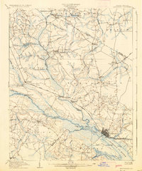
1905 Map of Chocowinity
USGS Topo · Published 1936About this map
The Tar River serves as the central artery for this early 20th-century landscape, where river landings and ferries still dictated the flow of commerce and travel through Beaufort County and Pitt County. Significant maritime transit is evidenced by the Steamboat Ferry Route and established landings such as Yankee Hall Ldg. and Grimes Ldg., which connected the interior swamps to the regional hub at Washington.
Find a feature on this map
74 named features on this map. Tap any name to fly to it.
Don’t see what you’re looking for? This feature index may not catch every label — zoom into the map to look around manually.
Map Details
Editions of this 1905 Chocowinity Map
3 editions found

Other maps of this area

1901 · Parmele
USGS Topo · 1:62,500

1901 · Williamston
USGS Topo · 1:62,500

1902 · Williamston
USGS Topo · 1:62,500

1902 · Parmele
USGS Topo · 1:62,500

1902 · Ayden
USGS Topo · 1:62,500

1902 · Vanceboro
USGS Topo · 1:62,500

1903 · Winterville
USGS Topo · 1:62,500

1903 · Chocowinity
USGS Topo · 1:62,500

1904 · Ayden
USGS Topo · 1:62,500

1904 · Vanceboro
USGS Topo · 1:62,500