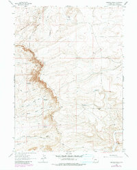
1963 Map of Chrisman Ranch
USGS Topo · Published 1980About this map
The Chrisman Ranch serves as a lone human waypoint in this high-desert landscape of Sweetwater County, which was extensively documented during the early 1960s and updated via aerial photography in 1977. The terrain is dominated by the massive Blue Rim escarpment, where multiple drainages like the North Branch Water Gap Wash and South Branch Water Gap Wash cut through the elevation. Water management is a primary theme of the settlement pattern here, evidenced by a string of livestock or irrigation catchments including Blue Rim Res No 2, Blue Rim Res No 3, and Blue Rim Res No 4. The map reveals a network of primitive transportation via a Trail and several Jeep Roads that navigate the Badlands Hills and connect remote features like Alkali Spring.
Find a feature on this map
21 named features on this map. Tap any name to fly to it.
Don’t see what you’re looking for? This feature index may not catch every label — zoom into the map to look around manually.
Map Details
Editions of this 1963 Chrisman Ranch Map
2 editions found
Other maps of this area

1954 · Rock Springs
USGS Topo · 1:250,000

1958 · Rock Springs
USGS Topo · 1:250,000

1961 · Scott Spring
USGS Topo · 1:24,000

1961 · Austin Ranch
USGS Topo · 1:24,000

1961 · Stevens Flat
USGS Topo · 1:24,000

1962 · Rock Springs
USGS Topo · 1:250,000

1963 · Gasson Bridge
USGS Topo · 1:24,000

1963 · Pittman Well
USGS Topo · 1:24,000

1963 · Big Island Bridge
USGS Topo · 1:24,000
1963 · Chrisman Ranch
USGS Topo · 1:24,000