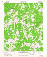
1966 Map of Chula
USGS Topo · Published 1967About this map
The Appomattox River carves a winding path across this rural landscape, forming the natural boundary between Powhatan and Amelia counties. In the mid-1960s, the area remained deeply connected to its agricultural roots, evidenced by the numerous cemeteries and community centers such as Grub Hill Ch, Liberty Ch, and Pine Grove Ch. The settlement of Chula serves as a local hub along the Southern railroad line, while smaller communities like Fieldstown and Masons Corner dot the interior crossroads. The terrain is defined by a dense network of tributaries including Flat Creek, Nibbs Creek, and Fighting Creek, which historically dictated the placement of early homes and farms. Aviation interest is noted at the Hill Top Airport, providing a modern contrast to the traditional creek-side settlements and rural schoolhouses like Brick Church Sch.
Find a feature on this map
33 named features on this map. Tap any name to fly to it.
Don’t see what you’re looking for? This feature index may not catch every label — zoom into the map to look around manually.
Map Details
Editions of this 1966 Chula Map
3 editions found
Other maps of this area

1890 · Goochland
USGS Topo · 1:125,000

1891 · Palmyra
USGS Topo · 1:125,000

1891 · Farmville
USGS Topo · 1:125,000

1892 · Goochland
USGS Topo · 1:125,000

1893 · Farmville
USGS Topo · 1:125,000

1895 · Palmyra
USGS Topo · 1:125,000

1897 · Amelia
USGS Topo · 1:125,000

1897 · Palmyra
USGS Topo · 1:125,000

1943 · Fine Creek Mills
USGS Topo · 1:31,680

1943 · Powhatan
USGS Topo · 1:31,680