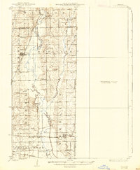
1924 Map of Chula
USGS Topo · Published 1938About this map
Medicine Creek and its many tributaries, including Little Muddy Creek and Crooked Creek, define the landscape of northern Livingston County during the early 1920s. This agricultural region is punctuated by a dense network of one-room schools such as Brush College School, Manning School, and White Cloud School, reflecting the rural community structure of the era. The presence of these institutions, alongside family and community burial grounds like Stucker Cemetery and Plainview Cemetery, provides a detailed view of local settlement patterns before modern consolidation.
Find a feature on this map
51 named features on this map. Tap any name to fly to it.
Don’t see what you’re looking for? This feature index may not catch every label — zoom into the map to look around manually.
Map Details
Editions of this 1924 Chula Map
3 editions found
Other maps of this area

1921 · Chillicothe
USGS Topo · 1:62,500

1923 · Chillicothe
USGS Topo · 1:62,500

1924 · Dawn
USGS Topo · 1:62,500

1924 · Chula
USGS Topo · 1:62,500

1924 · Hale
USGS Topo · 1:62,500

1946 · Brookfield
USGS Topo · 1:62,500

1946 · Galt
USGS Topo · 1:62,500

1947 · Chula
USGS Topo · 1:62,500

1948 · Brookfield
USGS Topo · 1:62,500

1948 · Trenton
USGS Topo · 1:62,500