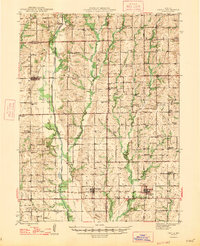
1947 Map of Chula
USGS Topo · Published 1947About this map
Medicine Creek and its many tributaries, including Muddy Creek and Parson Creek, dominate the central corridor of this post-war rural landscape. The map reveals a dense network of country schools and churches that served a widely dispersed farming community, with notable institutions like Mt Gilead Sch, Eureka Ch, and Jacksnipe Sch anchoring their respective neighborhoods. The region's economy and transport are clearly defined by the paths of major railroads, with the Chicago Milwaukee St Paul and Pacific running north-south through Chula and the Chicago Burlington and Quincy crossing east-west through Wheeling and Meadville. This intersection of rail lines and early highways highlights the importance of these small hubs for the agricultural trade of the era. Genealogists will find a wealth of local landmarks, from the Stucker Cem to the isolated Airway Beacon, reflecting the early years of modern aviation navigating over traditional Missouri farmland.
Find a feature on this map
89 named features on this map. Tap any name to fly to it.
Don’t see what you’re looking for? This feature index may not catch every label — zoom into the map to look around manually.
Map Details
Editions of this 1947 Chula Map
3 editions found
Other maps of this area

1921 · Chillicothe
USGS Topo · 1:62,500

1923 · Chillicothe
USGS Topo · 1:62,500

1924 · Dawn
USGS Topo · 1:62,500

1924 · Chula
USGS Topo · 1:62,500

1924 · Hale
USGS Topo · 1:62,500

1946 · Brookfield
USGS Topo · 1:62,500

1946 · Galt
USGS Topo · 1:62,500

1947 · Chula
USGS Topo · 1:62,500

1948 · Brookfield
USGS Topo · 1:62,500

1948 · Trenton
USGS Topo · 1:62,500