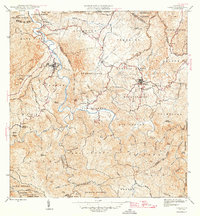
1946 Map of Ciales
USGS Topo · Published 1946About this map
Ciales and Morovis anchor this 1940s topographic study of the central mountain region, where the steep terrain is deeply incised by the Rio Grande de Manati. The map details a landscape transition from the concentrated town centers to scattered agricultural estates, notably Hacienda Maria and Hacienda Reynes. The social fabric of the era is evident in the placement of religious and educational landmarks, such as Iglesia Ascension, Iglesia del Niño Jesus, and the Escuela Segunda Unidad de Pesas in the Pesas barrio. Surveyed just after the war, the map captures a network of municipal boundaries including Municipio de Orocovis and Municipio de Vega Baja, alongside early infrastructure like the Linea de Transmision cutting across the north.
Find a feature on this map
90 named features on this map. Tap any name to fly to it.
Don’t see what you’re looking for? This feature index may not catch every label — zoom into the map to look around manually.
Map Details
Editions of this 1946 Ciales Map
3 editions found
Other maps of this area

1937 · Aguadilla
USGS Topo · 1:20,000

1937 · Moca
USGS Topo · 1:20,000

1938 · Alto Sano
USGS Topo · 1:20,000

1938 · San Sebastian
USGS Topo · 1:20,000

1938 · Quebradillas
USGS Topo · 1:20,000

1939 · Mayaguez
USGS Topo · 1:30,000

1941 · Moca
USGS Topo · 1:30,000

1941 · Rincon
USGS Topo · 1:30,000

1941 · Rincon
USGS Topo · 1:30,000

1941 · San Sebastian
USGS Topo · 1:30,000
Featured Places
- Sector Serrano, San Sebastián
- Sector La Grúa, Añasco
- Sector Los Crespos, San Sebastián
- Sector Ramos, San Sebastián
- Sector Los Ramos, Moca