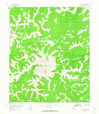
1952 Map of Circle A-4
USGS Topo · Published 1964About this map
Far Mountain stands as the central topographic focal point in this 1952 survey of the Fairbanks North Star region. The landscape is defined by the convergence of the North Fork Chena River and the East Fork Chena River, which carve deep drainage patterns through the high terrain. In this era, the area remained largely inaccessible by road, with the map noting that no roads or trails existed in the region at the time of the 1951 aerial photography. Small, isolated landmarks like Jones Pass and family-named watercourses such as Munson Creek and La More Creek provide the only markers of human identification in an otherwise unsurveyed wilderness. Geologists and local historians can use this map to trace the original, unaltered hydrology of the Monument Creek and Rosebud Creek basins before later development or natural shifts changed these remote corridors.
Find a feature on this map
16 named features on this map. Tap any name to fly to it.
Don’t see what you’re looking for? This feature index may not catch every label — zoom into the map to look around manually.
Map Details
Editions of this 1952 Circle A-4 Map
4 editions found
Other maps of this area

1950 · Big Delta
USGS Topo · 1:250,000

1951 · Big Delta
USGS Topo · 1:250,000

1951 · Circle
USGS Topo · 1:250,000

1951 · Circle A-5
USGS Topo · 1:63,360

1952 · Circle A-4
USGS Topo · 1:63,360

1952 · Circle B-4
USGS Topo · 1:63,360

1952 · Circle A-5
USGS Topo · 1:63,360

1954 · Circle A-5
USGS Topo · 1:63,360

1954 · Circle B-5
USGS Topo · 1:63,360

1955 · Circle B-3
USGS Topo · 1:63,360