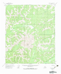
1952 Map of Circle A-4
USGS Topo · Published 1983About this map
The North Fork Chena River and Middle Fork Chena River define this interior Alaskan landscape, which remained largely unsurveyed and unmarked at the time of the 1951 aerial photography used for this map. Rising between these drainages is Far Mountain, a central landmark in a terrain dominated by significant elevation changes and numerous named tributaries. The Fairbanks North Star Borough Boundary cuts across the northern and southeastern sections, marking the political divide in a region where travel was dictated by natural corridors like Jones Pass. The map highlights several survey markers, including Vabm 4694 and VABM 3327 Monument, which served as the primary fixed points for mapping this wilderness. Waterways such as Monument Creek, Boulder Creek, and Sullivan Creek provide the only named geographic structure in this roadless territory.
Find a feature on this map
19 named features on this map. Tap any name to fly to it.
Don’t see what you’re looking for? This feature index may not catch every label — zoom into the map to look around manually.
Map Details
Editions of this 1952 Circle A-4 Map
4 editions found
Other maps of this area

1950 · Big Delta
USGS Topo · 1:250,000

1951 · Big Delta
USGS Topo · 1:250,000

1951 · Circle
USGS Topo · 1:250,000

1951 · Circle A-5
USGS Topo · 1:63,360

1952 · Circle A-4
USGS Topo · 1:63,360

1952 · Circle B-4
USGS Topo · 1:63,360

1952 · Circle A-5
USGS Topo · 1:63,360

1954 · Circle A-5
USGS Topo · 1:63,360

1954 · Circle B-5
USGS Topo · 1:63,360

1955 · Circle B-3
USGS Topo · 1:63,360