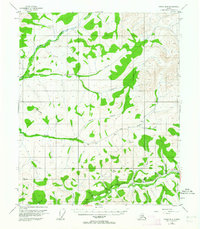
1954 Map of Circle B-6
USGS Topo · Published 1964About this map
The Chatanika River valley and its surrounding highlands reveal a landscape shaped by mid-century resource extraction and transportation. The Steese Highway serves as the primary artery through this interior terrain, linking the US Camp and various mining operations to the broader region. Evidence of gold-seeking history is prominent along the waterways, where several Placer Mines and a large-scale Ditch system underscore the industrial efforts to redirect water for hydraulic mining. To the north, the geography is defined by a dense network of drainages including Nome Creek, Champion Creek, and Little Champion Creek. High points like Table Top Mtn and the survey marker at VABM 3115 Cripple provide vantage points over this complex watershed. Scattered Cabins suggest a seasonal or transient presence of miners and trappers in the hills between Moose Creek and Sumner Creek.
Find a feature on this map
27 named features on this map. Tap any name to fly to it.
Don’t see what you’re looking for? This feature index may not catch every label — zoom into the map to look around manually.
Map Details
Editions of this 1954 Circle B-6 Map
4 editions found

Other maps of this area

1945 · Livengood
USGS Topo · 1:250,000

1951 · Livengood
USGS Topo · 1:250,000

1951 · Circle
USGS Topo · 1:250,000

1951 · Circle A-5
USGS Topo · 1:63,360

1951 · Livengood C-1
USGS Topo · 1:63,360

1951 · Circle C-6
USGS Topo · 1:63,360

1952 · Livengood A-1
USGS Topo · 1:63,360

1952 · Circle C-5
USGS Topo · 1:63,360

1952 · Circle A-5
USGS Topo · 1:63,360

1954 · Circle C-5
USGS Topo · 1:63,360