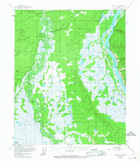
1955 Map of Circle C-1
USGS Topo · Published 1967About this map
Birch Creek dominates this interior landscape, weaving a complex network of oxbows and marshlands across the central terrain. Along its banks, the Steese Highway provides a terrestrial link through the wilderness, passing the site of Twelvemile House (Aban'd), a vestige of the region's early roadhouse history. To the west, the Crazy Mountains rise sharply, feeding tributaries like North Fork Crazy Creek into the low-lying basin.
Find a feature on this map
15 named features on this map. Tap any name to fly to it.
Don’t see what you’re looking for? This feature index may not catch every label — zoom into the map to look around manually.
Map Details
Editions of this 1955 Circle C-1 Map
3 editions found
Other maps of this area

1951 · Charley River
USGS Topo · 1:250,000

1951 · Circle
USGS Topo · 1:250,000

1952 · Circle D-2
USGS Topo · 1:63,360

1955 · Circle B-1
USGS Topo · 1:63,360

1955 · Circle C-2
USGS Topo · 1:63,360

1955 · Circle D-1
USGS Topo · 1:63,360

1955 · Circle B-2
USGS Topo · 1:63,360

1955 · Circle C-1
USGS Topo · 1:63,360

1955 · Circle
USGS Topo · 1:250,000

1956 · Charley River C-6
USGS Topo · 1:63,360