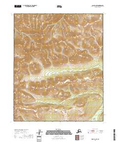
2018 Map of Circle C-6 SW
USGS Topo · Published 2018About this map
Bear Creek meanders through the central and southern reaches of this interior Alaskan landscape, serving as the primary drainage for a series of high-elevation ridges. The terrain is defined by a dense network of steep drainages, including Sheep Creek and Mascot Creek in the north and Willow Creek along the western boundary. At this stage of the 21st century, the area remains largely undeveloped, lacking the roads or structures common to more accessible regions. Instead, the map detail focuses on the complex topography and the hydrography of the Yukon-Koyukuk Census Area, illustrating how the headwaters of these various creeks carve into the upland slopes. The spatial organization is anchored by the Public Land Survey System grid, specifically marking the boundaries of T9n R4e, T9n R5e, T8n R4e, and T8n R5e.
Find a feature on this map
8 named features on this map. Tap any name to fly to it.
Don’t see what you’re looking for? This feature index may not catch every label — zoom into the map to look around manually.
Map Details
Editions of this 2018 Circle C-6 SW Map
This is the sole edition of this map. No revisions or reprints were ever made.
Other maps of this area

1945 · Livengood
USGS Topo · 1:250,000

1951 · Livengood
USGS Topo · 1:250,000

1951 · Circle
USGS Topo · 1:250,000

1951 · Livengood C-1
USGS Topo · 1:63,360

1951 · Circle C-6
USGS Topo · 1:63,360

1954 · Circle B-6
USGS Topo · 1:63,360

1954 · Livengood C-1
USGS Topo · 1:63,360
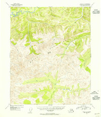
1954 · Circle C-6
USGS Topo · 1:63,360

1954 · Livengood B-1
USGS Topo · 1:63,360

1955 · Circle
USGS Topo · 1:250,000