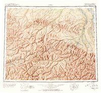
1951 Map of Circle
USGS Topo · Published 1954About this map
The Yukon River defines the northeastern boundary of this 1951 study, where the river meets the settlement of Circle. This landscape is dominated by the massive ridge systems of the White Mountains and Crazy Mountains, which are pierced by the Steese Highway. This vital road link connects the interior to the Yukon, passing through historically significant waypoints such as Central House, Miller House, and over the high elevations of Eagle Summit.
Find a feature on this map
73 named features on this map. Tap any name to fly to it.
Don’t see what you’re looking for? This feature index may not catch every label — zoom into the map to look around manually.
Map Details
Editions of this 1951 Circle Map
4 editions found

Other maps of this area

1945 · Livengood
USGS Topo · 1:250,000

1949 · Fairbanks D-1
USGS Topo · 1:62,500

1950 · Fairbanks
USGS Topo · 1:250,000

1950 · Big Delta
USGS Topo · 1:250,000

1950 · Big Delta D-6
USGS Topo · 1:63,360

1951 · Big Delta
USGS Topo · 1:250,000

1951 · Fort Yukon
USGS Topo · 1:250,000

1951 · Charley River
USGS Topo · 1:250,000

1951 · Eagle
USGS Topo · 1:250,000

1951 · Black River
USGS Topo · 1:250,000